Weather forecasters say they are becoming more concerned about the potential of widespread severe thunderstorms with damaging winds, large hail, and strong tornadoes on Sunday across the quad-state area, including western Kentucky.
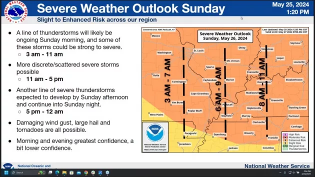
During a severe weather conference Saturday afternoon, Senior Forecaster Keith Cooley with the National Weather Service in Paducah said the entire area is under an enhanced risk of severe thunderstorms anytime from before daybreak Sunday morning through midnight. He noted that all severe weather threats are possible during this time frame.
According to Cooley, the first round of severe weather is expected to move through western Kentucky from 6 am through 11 am.
click to download audioAs we go into the early afternoon hours, Cooley indicated the atmosphere will start to destabilize touching off more desecrate-type supercells with all risks possible.
click to download audioAfter the scattered severe thunderstorms from 11 am to 5 pm, another line of severe thunderstorms will move into the area Sunday afternoon into Sunday night.
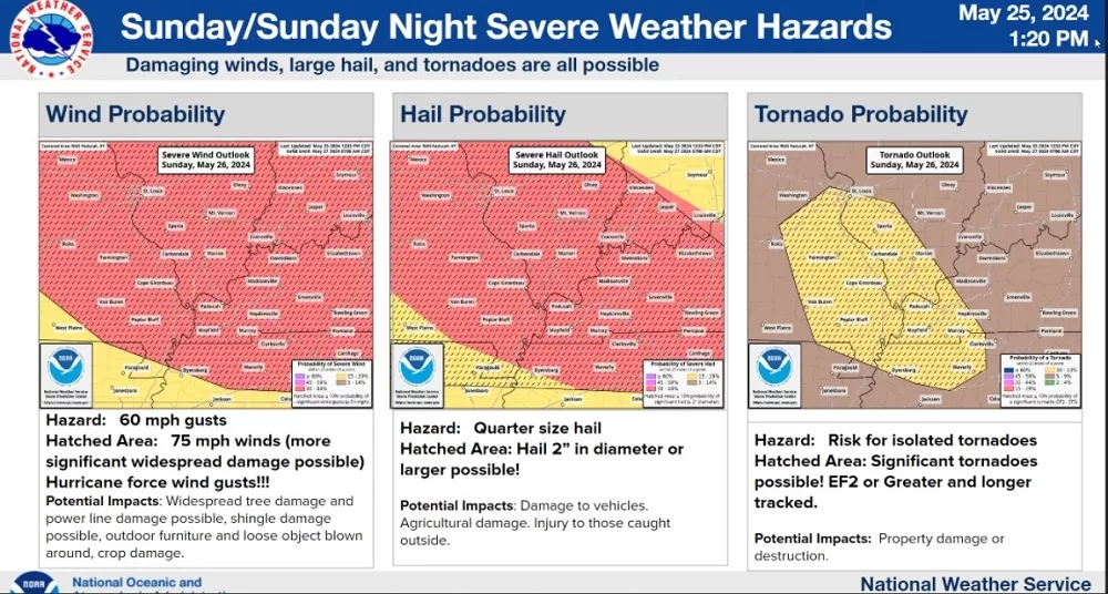
click to download audioHe said hurricane-force wind gusts of up to 70 mph are also possible with any of the severe storms that move through the area.
click to download audioCooley said there is also the potential for damaging hail 2-inch in diameter and larger, along with significant, strong long-tracking tornadoes.
In addition, the National Weather Service has issued a flash flood watch for western Kentucky from 1:00 Sunday morning through 7:00 Monday morning with heavy rainfall of 1 to 2 inches an hour possible in some areas.
He emphasized the threat of severe weather is possible all day Sunday through midnight.
To ensure you receive any timely watches or warnings, make sure you have a way to receive weather alerts. In addition, Cooley suggests identifying sturdy structure options in advance and knowing where to go if a warning is issued, which can significantly increase your safety during a weather event so that you are prepared and not caught off guard.