


The weather has kept us on our toes this season with major hurricanes, wildfires, and flip-flopping weather patterns. It has been hard to keep up with the very changeable weather patterns. So I am going to do sort of a shotgun approach with this post and talk about a couple of things on my mind at this point in our weather.
First, let’s talk about the fall colors. Fall is here and you can finally see colors starting to show across our forests.  Total change overall is 40 %. Colder temperatures and rain is the forecast which will no doubt bring more changes. Some of the prettiest colors are beginning to turn right now: the oranges of the sugar maples, the golds of the hickories, and the reds of Virginia creeper.
The understory has a lot of red color, with dogwoods and sumacs pretty much fully in red now. But, we’re ending October and starting November, and most trees and bushes still look boring. They are just not as vibrant as years past. Why? You can thank the warm and dry weather the state has experienced at the end of September and the first half of October. Temperatures up until the last two or three weeks have been 10 to 15 degrees warmer than normal.  When the weather is warm, plants and trees produce more chlorophyll, the pigments that cause plants to turn green. Fall and winter seasons bring, obviously, cooler weather, which has now arrived. So that means our beautiful fall foliage will not be as vibrant and will be later than normal.
Now on to another topic. A lot of folks have asked how I know when colder weather is coming. One of the things I watch for during this time of year is the tracks of typhoons in the Pacific Ocean. A storm system is forecast to develop for the last weekend in October as the northern jet stream…the slithering river of high altitude winds…plunges south over eastern North America this weekend. This dip is a see-saw-like response to a massive bulge in the jet stream expected to develop over western North America, thanks in part to former Typhoon Lan in the Pacific.
One of the most interesting aspects of this typhoon will be how it will affect the weather 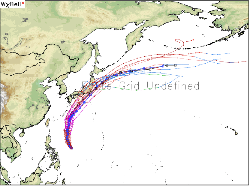 thousands of miles away, including across the East Coast of the U.S. during the next week or so. When typhoons, particularly powerful ones like Lan, recurve into the northern Pacific Ocean, they can give a jolt to the jet stream flowing from west to east across the Pacific Ocean. The jet stream, which is a narrow highway of strong winds at about 30,000 feet above the Earth’s surface that steers weather systems, tends to become more amplified, or wavier, in the days after a strong typhoon recurves into the northern Pacific Ocean.
These waves in the jet stream can spawn storms and outbreaks of cold air across North America, and are part of what long-range weather forecasters look for when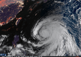 making a prediction. That a typhoon near Japan could have a ripple effect on the weather in Detroit and New York just a few days later may be difficult to fathom, but it illustrates the different ways in which the world is an interconnected place. Making matters worse, the typhoon may serve to reinforce a long-running weather pattern that has favored warm and dry conditions in the West, where California is having record numbers of wildfires.
Recurving typhoons like Lan increase the risk of extreme weather across North America about five to 10 days after it recurves, especially in October or November. During this time frame, the jet stream tends to be stronger, typhoons tend to be stronger, and upstream areas of low pressure  tend to be more intense as well, because the air flowing out of the typhoon gets funneled into the North Pacific jet stream. This adds energy to the jet, which “perturbs” it, While Lan is no longer a threat to land, a new tropical storm is expected to take a similar track this week.
Tropical Storm Saola brought gusty showers to Guam as it passed south of the island before threatening Japan. While passing over the open waters of the western Pacific Ocean, Saola will strengthen and will become a typhoon. This storm is also expected to recurve north and east. While it isn’t as powerful as Lan was, it will help to keep the cold air flow coming over the next couple of weeks. Please feel free to comment and leave your name. Be sure to hit the “Like” button at the bottom.