I am looking at the weather too much lately. But now there are new signs that something is up. This time it isn't in the tropics. The teleconnections are going deeper than I have seen them in years. Almost to the extreme.
But no one seems to be talking about it yet which has me second guessing what I am seeing. There is no doubt in my mind the coming pattern is there, the models see the signals too. So, I am going to give you a little lesson in weather and explain what I am seeing.
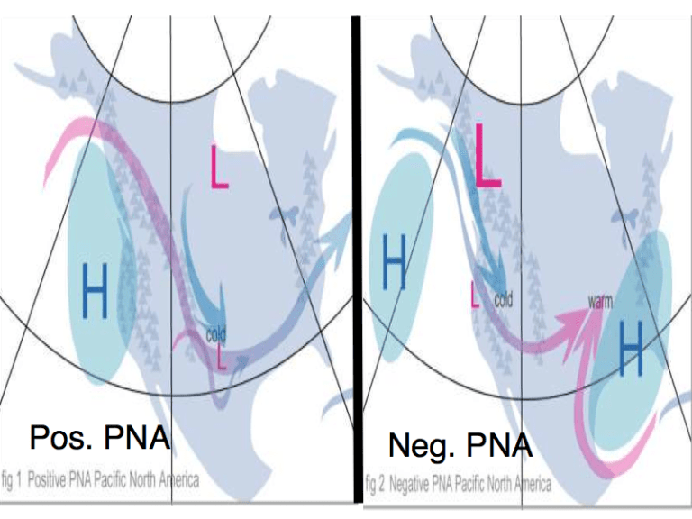
We are talking about upper air currents that form patterns. These are also called teleconnections. There are three different patterns that normally have a large influence on our weather specifically in the fall and winter. The first upper air current is called The Pacific/North American pattern (PNA), and is a large teleconnection that dominates weather from Shanghai, China, to Atlanta, Georgia, every month except June and July.
When the difference in air pressure between two designated points within an atmospher ic oscillation is great, conditions are described as “positive.” When the difference is low, conditions are “negative.” As the PNA turns negative, the airflow becomes more directly west-to-east. A positive PNA, like we have now, carries tropical moisture into British Columbia, and the United States ends up with cold and stormy weather in the Midwest and Southeast; cold in the East and warmth in the West; and tornadoes—and even snowstorms—along the Gulf Coast, as blasts of polar air meet warm, moist air in the South.
A negative PNA carries diminishing amounts of moisture eastward from California, resulting in cold and snowy weather in the West; rain and snow in the plains; and warm and relatively dry weather in the East. The PNA is currently going very positive. Make a note of that. The next upper air pattern that has a great effect on us is the Arctic Oscillation or AO.
The degree to which Arctic air penetrates into middle latitudes is related to the AO index, which is defined by surface atmospheric pressure patterns. When the AO index is positive, surface pressure is low in the polar region. This helps the middle latitude jet stream to blow strongly and consistently from west to east, thus keeping cold Arctic air locked in the polar region. When the AO index is negative, there tends to be high pressure in the polar region, weaker zonal winds, and greater movement of frigid polar air into middle latitudes.
The AO is a climate pattern characterized by winds circulating counterclockwise around the Arctic at around 55°N latitude. When the AO is in its positive phase, a ring of strong winds circulating around the North Pole acts to confine colder air across Polar Regions. This belt of winds becomes weaker and more distorted in the negative phase of the AO, which allows an easier southward penetration of colder, arctic airmasses and increased storminess into the mid-latitudes. The AO is currently strongly negative. Another thing to take note of.
Finally, there is The North Atlantic Oscillation (NAO) affects the eastern United States. This teleconnection sits between the cool atmospheric low over Iceland and the warm high over the Azores. In winter, a positive NAO causes Atlantic storms to veer north, and warm, wet winters t o occur in the eastern United States and Europe. Northeastern Canada tends to be unusually cold. In summer, a positive NAO means fewer tropical storms and hurricanes striking the East Coast. In winter, a negative NAO, as we have now, forces cold air into the eastern United States, and causes heavy rains in southern Europe. Northeastern Canada is generally warmer, and areas around the Great Lakes tend to have a cooler, wetter spring. The NAO is currently strongly negative.
So we have a positive PNA, a negative AO, and a negative NAO, all at the same time. With the AO/NAO predicted to be negative at least up to the third week of October confidence is growing that a strengthened Siberian high and a weakened polar vortex with the negative AO this upcoming winter, means very cold temperatures across the continents of the northern Hemisphere.
The first attack of the cold will come the last few days of October and specifically around Halloween. I am not saying snow right now but it looks downright cold. And it looks like that cold could be around as we open up November too. Feel free to leave comments and be sure to hit the “Like” button at the bottom of this post.