
With most of the Quad State region still sitting in moderate-to-severe drought conditions to open this week, rain gauges are finally going to see some action.
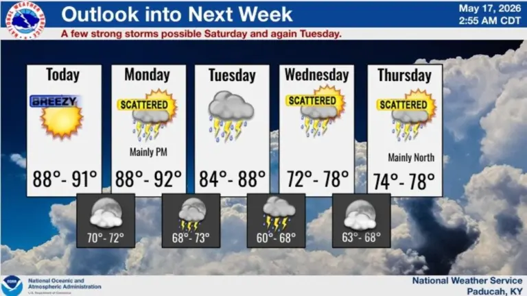
That’s according to Paducah National Weather Service Lead Forecaster Keith Cooley, who during Monday morning’s weekly conference noted that small chances of severe thunderstorms arrive this afternoon, with larger chances sweeping through Tuesday afternoon and night.
Chances for rain Tuesday, Cooley added, are between 80-and-100-percent for the entire service area, a bit of good news for the rain-starved region.
Wind and hail, he said, will be the main threats, with sheer decreasing late Tuesday, while “marginal” to “slight” risks of flash flooding are possible both days.
Drier conditions briefly arrive behind Tuesday’s cold front, leading into Wednesday, before wet weather returns Thursday, and likely through the weekend.
Over the next five days, Cooley said most locations in the Quad State region will receive anywhere between 1-to-2 inches of rainfall, with some locations receiving up to 3 inches.
As such, school officials across southeast Missouri, southern Illinois, western Kentucky and southern Indiana may want to review late-week plans for outdoor graduation celebrations.
Meanwhile, the latest drought monitor, Cooley said, isn’t positive.
For reference, Cooley said Cape Girardeau, Missouri, is 9.73 inches below normal since January 1, Paducah is at 8.95 inches below normal, Carbondale is 7.18 inches below normal, and Evansville is 7.38 inches below normal.
These storms won’t be drought-busters, but in the 8-to-14-day weather calendar, Cooley said this region should expect “above average” temperatures, as well as “above average” precipitation.