We are now in the first full week of October so I thought I would update you on how things are stacking up as far as the long range outlooks go.
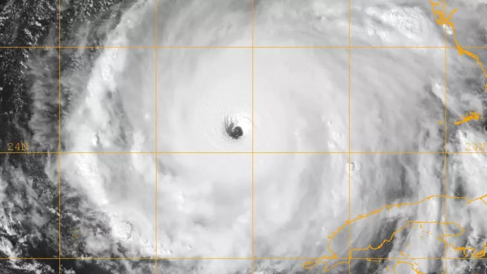
In my blog of September 18th, I pretty well hit it right on the money as to when the fall weather would arrive and what triggered it. So now that we are in October, where do we head from here? You may also remember that I said to watch the tropics. Now we have  Category 4 Hurricane Matthew in the Atlantic and Super Typhoon Chaba in the Pacific…also known as Chaba the Hut. (There must be a Star Wars fan out there in the Pacific). Chaba has just been upgraded to the equivalent of a Category 5 Atlantic hurricane. It is packing winds of 165 mph and increasing.
Both of these storms will have an indirect influence on our weather. You will notice temperatures this week are somewhat warmer than what we have seen over the last week or so. We can thank “Matthew” for that. It is forcing a ridge of warmth to move westward over our region. At the same time, a trough and cold front is slowly approaching from the west. If Matthew slows down, (which I think it will), and it is just off the GA coast on Friday as the front arrives, the front will have a lesser impact on our area with only a few showers and cooler Saturday & Sunday, just not as cool as it could have been. However, if it continues the present speed and remains a little more out to sea, then it will likely be cooler when the front arrives sometime Friday night.
One thing Matthew will do is to suppress the heat ridge to the point it will not return until next year. Now to the Pacific….Chaba is a Category 5 storm, and is expected to strengthen. It is thought it will make a turn to the north then northeast passing over Okinawa and grazing Japan. The tracks of western Pacific typhoons can give us important clues about how weather patterns will change over North America in the following 7-10 days. Specifically, a recurving typhoon like Chaba is often a sure sign of a deep trough developing over North America the next week. That means much cooler, maybe stormy, fall weather for western Kentucky.
The models are already picking up on an impressive cool to cold air outbreak arriving in our area around the 14th or 15th, give or take a day or so. The upper air currents also indicate something brewing and are leaning toward a +PNA, -NAO and fairly significant -AO. This almost always spells a storm coming. Then, I looked even further out in the models and there seems to be an even more powerful storm coming somewhere around the end of October. The cold associated with that looks impressive. It should arrive in western Kentucky around the 29th or even on Halloween. It looks to me like it will be a chilly and wet time for trick or treaters. November looks fairly normal until the end of the month. I expect a storm and cold front just before or during Thanksgiving. It is way too early for any details on that if it even happens.
December will have shots of cold air and we may see a few snowflakes in the air around the 8th. I think our friend, the Polar Vortex pays us a visit just before Christmas with some seriously cold air. We will have to wait until it gets closer before we can say anything on that as far as details. Remember the summer and how it just didn’t seem to end? It will feel like an extended win ter for us and most folks in the eastern U.S., as cold and snowy conditions stretch into spring 2017. Now, having said all this, please remember that these are just outlooks and trends and are not actual forecasts. Lots of things can and probably will change.
I have been blessed by being correct on most of my long range thoughts up to this point. But we are entering a period where it becomes more difficult to be accurate over a long range of time. So keep that in mind and take this with a grain of salt. Before I forget, one last thing…the cloudy days we have been having will help the leaves to have more yellow colors than last year. The shade of colors are based the amount of light the leaves get as they start to turn. Cloudy days equals more yellow and gold while sunny days equal more reds and browns. This year should feature a good mixture of both. Feel free to leave comments and be sure to hit the “Like” button at the bottom of this post.


