


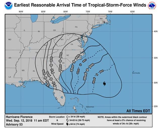
There’s never been a storm like Florence. It was located farther north in the Atlantic than any other storm to ever hit the Carolinas. Evacuations began on Tuesday morning as people living near the coasts of South Carolina, North Carolina and Virginia fled inland. Traffic patterns were altered to help speed up evacuation efforts, including lane reversals on several major roads in South Carolina.
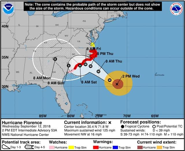
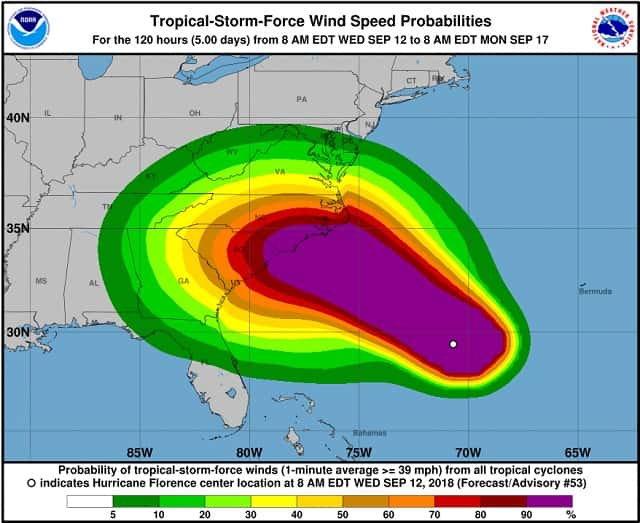
Residents in the path of the storm have been stocking up for days, leading to long lines at gas stations and empty shelves at grocery stores all across the region. Some gas stations have already run out of fuel. Hurricane and storm surge warnings are now in effect for a large swath of the Eastern Seaboard, stretching through eastern South and North Carolina as well as into far southeastern Virginia. Residents are urged to prepare for catastrophic damage from wind and storm surge.
Fuel shortages are increasing across the Carolinas as residents prepare to evacuate, draining local gas stations’ supplies. Anti-price-gouging laws are now in effect in North Carolina and South Carolina; anyone witnessing exorbitant prices on gas, lodging or food along evacuation routes can complain to the attorney general’s office. Data from an Air Force Reserve hurricane hunter aircraft along with satellite imagery and various intensity estimates indicate that Florence has weakened instead of strengthening. However, while the hurricane hasn’t strengthened in terms of peak winds, the inner-core and outer wind fields have continued to expand, resulting in an increase the cyclone’s total energy, which will create a significant storm surge event. The upper-level outflow remains impressive and is still expanding except toward the south.
According to the National Hurricane Center, a narrow window of opportunity remains during the next 24 hours or so for Florence to strengthen a little when the hurricane passes over the deeper warm water. However, significant strengthening is not anticipated due to Florence’s large and expanding inner-core wind field. By 36 hours out and beyond, decreasing ocean heat content along with the slowing forward speed of Florence will likely produce cold upwelling beneath the hurricane, inducing a gradual weakening trend. Although the maximum winds are expected to weaken a little more, Florence is still expected to remain a dangerous major hurricane as it approaches the coast. The threat to life from storm surge and rainfall will not diminish, and these impacts will cover a large area regardless of exactly where the center of Florence moves.
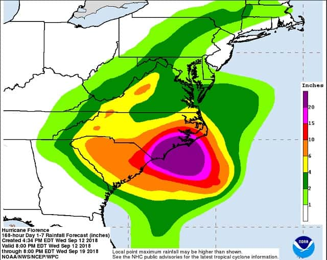
A life-threatening storm surge is now highly likely along portions of the coastlines of South Carolina and North Carolina, and a Storm Surge Warning is in effect for a portion of this area. All interests in these areas should complete preparations and follow any advice given by local officials. Life-threatening, catastrophic flash flooding and prolonged significant river flooding are likely over portions of the Carolinas and the southern and central Appalachians late this week into early next week, as Florence is expected to slow down as it approaches the coast and moves inland.
Damaging hurricane-force winds are likely along portions of the coasts of South Carolina and North Carolina, and a Hurricane Warning is in effect. Strong winds could also spread inland into portions of the Carolinas. Large swells affecting Bermuda, portions of the U.S. East Coast, and the northwestern and central Bahamas will continue this week, resulting in life-threatening surf and rip currents.